EPA Collaboration to Validate Satellite Air Quality Measurements
In the summer of 2023, EPA scientists measured a combination of pollutants and meteorological variables across the Long Island Sound region as part of a multi-agency research campaign involving the National Aeronautics and Space Administration (NASA), the National Oceanic and Atmospheric Administration (NOAA), and state partners in Connecticut, New York, and New Jersey.
On this page:
Summer Field Research
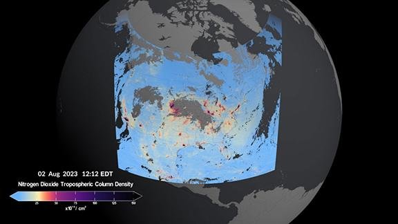
EPA researchers used air quality measurements from ground-based spectrometers to validate the first observations from NASA's Tropospheric Emissions: Monitoring of Pollution (TEMPO) satellite mission. TEMPO measures air pollutants in the atmosphere, including ozone, nitrogen dioxide, and formaldehyde, every hour across greater North America down to a neighborhood scale.
During this study, EPA scientists collected measurements with advanced technologies from ground and ship platforms to develop greater understanding of the underlying causes of high ozone in this region, particularly at shoreline monitoring locations. EPA scientists measured ozone, fine particulate matter (PM2.5) and ozone precursors (nitrogen dioxide and formaldehyde) from an EPA research vessel in the Long Island Sound. The measurements were taken approximately four meters above the surface of the water at the marine surface layer. Researchers also collected meteorological measurements, including wind, temperature, and pressure at the marine surface layer, along with vertical profiles of aerosols through the troposphere and the marine boundary layer (the part of the atmosphere that has direct contact with the ocean).

Study Partners
Federal partners:
- NASA
- NOAA
State partners:
- New Jersey Department of Environmental Protection
- New York State Department of Environmental Conservation
- Connecticut Department of Energy and Environmental Protection
Sensors Used
Using land-based Pandora spectrometer instruments, EPA scientists partnered with states to measure ozone, nitrogen dioxide and formaldehyde in different layers of the atmosphere. Measurements taken in collaboration with state partners include:
- Three-dimensional winds (horizontal and vertical) at the Connecticut Department of Energy and Environmental Protection’s (CTDEEP) Stratford, Conn. Lighthouse site;
- Surface formaldehyde at air monitoring sites at CTDEEP in Westport, Conn., New York Department of Environmental Conservation (NYDEC) in Old Field, N.Y. and Queens College, N.Y.; and
- Column abundances of ozone, nitrogen dioxide, formaldehyde, and surface nitrogen dioxide and formaldehyde at nine sites around the Long Island Sound. These nine sites are long-term CTDEEP, NYDEC and New Jersey Department of Environmental Protection (NJDEP) air quality monitoring sites.
EPA scientists operated a total of 25 Pandoras during the summer field intensive. Data from the Pandora instruments were also used to validate the first observations from the TEMPO satellite instrument.
Other measurement instruments used in this field research by EPA include:
- In-situ (surface) analyzers to detect ozone, nitrogen dioxide, carbon dioxide, fine particulate matter (PM2.5) and formaldehyde;
- Celiometers, remote sensing LiDARs that send pulses of light up (laser beams) through the atmosphere to help scientists analyze aerosol backscatter and identify how pollutants are mixing in the atmosphere;
- Wind LiDARs, ground-based devices that measure aerosol backscatter and three-dimensional air movement by shooting laser beams into the sky; and
EPA scientists, in collaboration with the Smithsonian Astrophysics Observatory and NASA, will help validate the next generation air quality measurements from space from the NASA TEMPO mission. EPA is co-leading the validation effort through the long-term deployment of ground-based Pandora spectrometers, providing measurements that support the research of NASA and NOAA field campaigns, and serving as a primary validation measurement for the TEMPO mission. Ground-level data will help scientists evaluate TEMPO observations to improve air pollution forecasts. Eventual findings will help inform decisions by state and local environmental officials about the most effective ways to reduce air pollution.
Related Links
- Tropospheric Emissions: Monitoring of Pollution (TEMPO) Smithsonian Home Page
- NASA’s Earth Observing System - TEMPO
- Remote Sensing Information Gateway 3D Data Inventory
