Air Sensor Collocation Opportunities
Air sensors are now more widely available for purchase and allow users to measure air quality in more places, more often, and at a lower cost than more traditional measurement methods, like regulatory air quality monitors. However, those advancements come with the cost of lower accuracy and higher uncertainty in the data they produce.
EPA and other researchers have found that an effective way to assess the performance of individual sensors is to check the sensor measurements against known, quality-assured, federal reference or equivalent method instruments – a process referred to as collocation. By comparing the two data sets, users can better understand how to interpret the sensor data by developing data correction equations or methods.
On this page:
Collocation Sites
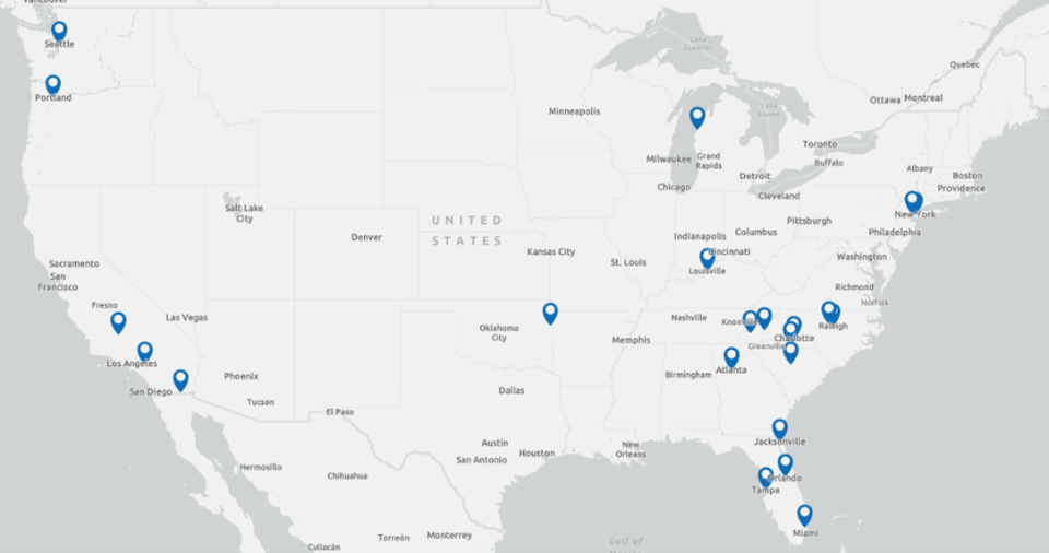
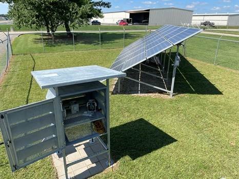
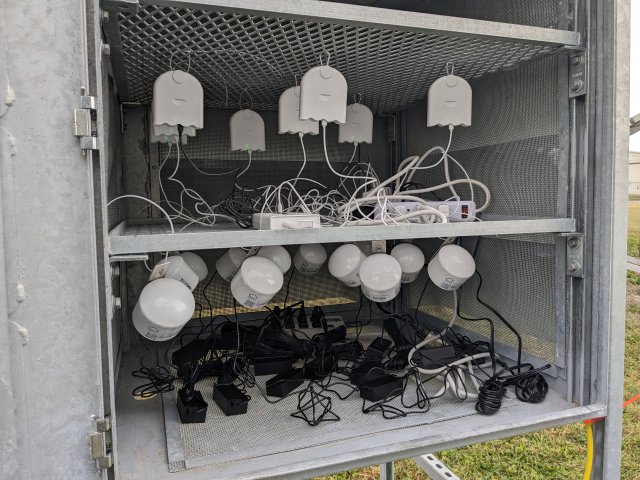
Several regulatory air monitoring agencies have established sites that can accommodate air sensor collocations. State, local, and Tribal agencies are often asked to support collocation efforts but may be limited by space and access. In 2020, EPA began an effort to design, build, and deploy a set of collocation shelters to sites across the country to increase the availability and accessibility of collocation opportunities. A collocation shelter is a metal, weather-shielding enclosure that can house several air quality sensors at once.
Lessons learned and best practices are summarized from current collocation shelter sites and include information on planning, building the shelter, collaborating and building relationships, and case studies.
Collocation shelter design documents are available for those interested in building a collocation shelter for their site.
Each collocation site is independently operated; eligibility, logistics, and the pollutants measured will vary. Each State/Local/Tribal air agency have specific monitoring purposes. They may measure a subset of a variety of possible pollutants such as, but not limited to: Particulate Matter 2.5 microns or less in diameter (PM2.5), Particulate Matter 10 microns or less in diameter (PM10), Sulfur Dioxide (SO2), Nitrogen Dioxide (NO2), Nitrogen Oxides (NOx), Carbon Monoxide (CO). See detailed information on this page provided by partners with collocation shelters or other collocation opportunities. Reach out to the site contact or view their website for additional information.

These sites enable individuals, communities, researchers, Tribal agencies, and air monitoring agencies to conduct more successful, informative, and quality-assured air sensor projects because air sensor performance can be checked up front. Individuals who utilize these resources may also benefit from better collaboration and communication with local air quality monitoring experts.
If your air monitoring agency is open to offering collocation opportunities and would like to be added to this list, please contact us.
Disclaimer: Mention of trade names or commercial products does not constitute U.S. EPA endorsement or recommendation for use.
Information on this page was last updated on 5/29/24. Please reach out to the site contacts listed for each collocation site for more information.
EPA Region 4
Jacksonville, Florida - Collocated Air Sensor Shelter (CASS)
The Collocated Air Sensor Shelter (CASS) is located at Henry L. Brown-Kooker Park (2900 Bennett St., Jacksonville, Fla. 32206). The shelter will be situated in a fenced in area adjacent (≤ 10 meters) to City of Jacksonville’s (COJ) ambient air monitoring site at the park and accessible through a gate on Bennett St. A lock will be used to control access to the shelter enclosure. The code will be given to anyone who has been approved to use the shelter. We ask each organization to label their sensors with their name and contact information (e.g., business card) so that there is no confusion about who the sensors belong to and to prevent the accidental collection of the wrong sensors when multiple groups are using the shelter. Sensor users can use the shelter provided there is enough space for their equipment at the site. If a new group requests to use the shelter and there is no space, the sensors that have been in place the longest will be asked to be removed first. Electricity and public Wi-Fi will be provided.
A variety of air pollutants are monitored at this site. This monitoring site uploads hourly PM2.5 and PM10 data to AirNow (AQS ID: 120310032). In addition, we provide higher time resolution data and pollutants not sent to AirNow via email to users on request.
The following is a comprehensive list of the pollutant of interest, the reference monitors in use at the monitoring site, and the time resolution. Data from all instruments listed may not be provided, due to unavailability or incompatibility with sensor data parameters.
- SO2 - Thermo Scientific 43i - 1 min.
- NO2 - Teledyne API T500 - 1 min.
- PM2.5 - Teledyne API T640X with PM1 - 1 min.
- PM10 - Teledyne API T640X with PM1 - 1 min.
Accessibility: The collocation shelter is located inside a city park with 24/7 access. It is at ground level, secured to the ground, and protected with a lock.
Eligibility: Anyone, no current restrictions (subject to change).
Apply: An application including a study design, sensor technologies used, and the study duration is required. The City of Jacksonville (COJ) requires all data collected on sensors while using the shelter be shared with COJ’s ambient air monitoring group.
Website: City of Jacksonville website. Currently no website for this program.
Additional information: Shelter installed March 2022.
Contacts:
- Janelle Ames ([email protected]) or (904) 255-7169
- Charles Farmer ([email protected]) or (904) 255-7414
- Michael Williams ([email protected]) or (904) 255-7120
Louisville, Kentucky - Cannons Lane Air Monitoring Station Collocation Shelter

The Louisville Metro Air Pollution Control District (APCD) operates a sensor collocation shelter at its Cannons Lane Air Monitoring Station. This allows community members to site their own sensors alongside APCD’s regulatory monitors. The site is part of the NCore Monitoring Network and a Photochemical Assessment Monitoring Stations (PAMS) site that collects minute-level data for PM, CO, SO2, NO2, NOx, and meteorology, in addition to hourly data for 60+ volatile organic compounds that are ozone precursors. The collocation shelter is inside the site fence line for security.
Accessibility: The collocation shelter is at ground level.
Eligibility: Citizens, researchers, and students who want to calibrate or learn more about air sensors. Those under 18 must be accompanied by an adult.
Apply: Visit the Louisville Metro APCD’s Air Sensors website.
Website: Louisville Metro APCD
Contact: Tom Lobb ([email protected])

EPA Region 9
Riverside, California – Mira Loma Van Buren Air Quality Sensor Collocation Shelter
The South Coast Air Quality Management District (South Coast AQMD) hosts an air quality sensor co-location shelter at its Mira Loma Van Buren Air Monitoring Station for the public to gather sensor data in proximity to regulatory monitors. The site provides real-time data for the following criteria pollutants: CO, NO2, O3, PM2.5, and PM10. The collocation shelter is inside the site’s fence line. Power is available on site. Datalogging and transmission (e.g., WiFi) is not provided and is the responsibility of the interested party.
The following is a list of criteria pollutants monitored and information of their corresponding reference instruments. Hourly resolution reference instrument data is readily publicly available; higher time resolution reference instrument data may be available upon request.
- CO: Horiba APMA360; Time resolution: 1 min.
- NO2: Teledyne API T200; Time resolution: 1 min.
- O3: Teledyne API T400; Time resolution: 1 min.
- PM2.5: MetOne BAM 1020; Time resolution: 1 hr.
- PM10: MetOne BAM 1020; Time resolution: 1 hr.
Accessibility: The collocation shelter is located next to Van Buren Elementary School and is at ground level. Access details will be provided by staff.
Eligibility: There is no specific restriction at the moment (subject to change).
Apply: Inquiries should be sent to contacts below and should include a short description of the project, proposed timeline/duration, and desired frequency of site access.
Website: South Coast AQMD's AQ-SPEC website
Contacts:
- Rene Bermudez ([email protected]) and also carbon copy (cc) [email protected]
Other Collocation Contacts
- The Association of Air Pollution Control Agencies (AAPCA)
- State and Local Air Pollution Control Agencies
Related Resources
The following resources can help air sensor users learn more about collecting and interpreting their air quality data:
- EPA’s Air Sensor Loan Programs: Resource to find air sensor loan programs from various organizations in collaboration with EPA.
- EPA’s Enhanced Air Sensor Guidebook: A guidebook to support users in planning and collecting air quality measurements using air sensors.
- EPA’s Air Sensor Toolbox and Collocation Guide: A website designed to help air sensor users learn about collection and the steps required to conduct a successful collocation.
- EPA’s Excel-based Macro Analysis Tool for Air Sensor Data: A tool to help community scientists and other non-experts compare data from their air sensors to regulatory monitors and interpret their results.
