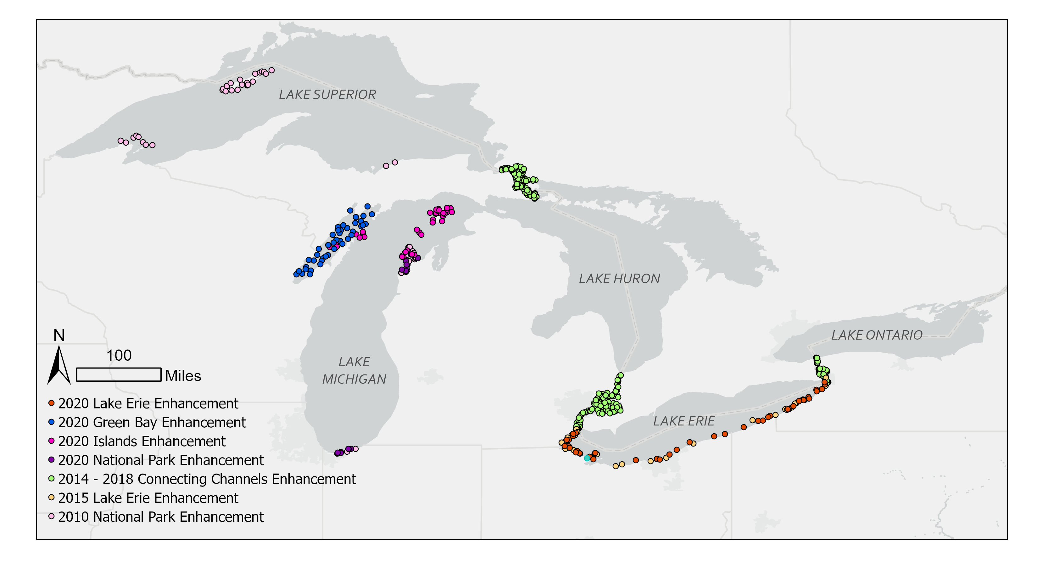
2020 Design Enhancements to Great Lakes National Aquatic Resource Surveys
EPA works closely with state and regional partners who rely on their data to make difficult decisions about where to invest environmental management resources. The National Coastal Conditions Assessment (NCCA) is a survey of the nearshore areas of the Great Lakes that is conducted every five years. EPA scientists solicited feedback from their state and regional partners to determine what additional information they need from the NCCA and design effective surveys to collect it.
To respond to state resource managers needs for more data about key areas in the Great Lakes ORD researchers started work on a series of pilot studies in certain areas based on the needs of state and regional managers. These enhancements include adding more sites, more resources and incorporating secondary data sources for assessments.
On This Page:
Adding Testing Sites to Increase Resource Reporting Units
- Lake Erie: During the summer water quality in Lake Erie often declines because of algal blooms caused by excessive nutrients delivered into the western basin of the lake. However, as this water circulates through the central and eastern basins nutrients are consumed and diluted, meaning that algal blooms in these areas are less frequent and severe. EPA enhanced the Lake Erie part of the NCCA survey to give state and regional managers information on conditions in each basin, allowing them to examine how harmful algal blooms affect these different areas of the lake.
- Embayments: An embayment is an indentation in the shoreline that extends inland farther than its width along the shore. Normally embayment areas would not be allocated many sampling sites because their surface area is very small compared to the rest of the nearshore. EPA scientists developed an embayment enhancement design to better understand conditions in the embayments compared to the rest of the nearshore. This was done because although embayments comprise only 5% of the nearshore area, they are thought to have disproportional influence on overall nearshore condition due to their connections to tributaries and watershed stressors.

Enhancing Resources for State and Regional Managers
- Connecting Channels: While plenty of attention is given to the Great Lakes, less is given to their connecting channels. To address this gap EPA scientists are assessing the condition of the connecting channels, the St. Marys River, the Lake Huron-Lake Erie Corridor, and the Niagara River. To help evaluate water quality EPA scientists compared the condition of the channels to each other and to the larger Great Lakes nearshore. As future NCCA surveys are conducted and further information about the ecological condition of the Great Lakes connecting channels are collected decision makers will be better able to assess changing conditions in these channels.
- Green Bay: Green Bay has a long history of research and restoration efforts due to historical impacts from industrial pollution and agricultural runoff from the Fox River watershed in the lower Green Bay. EPA scientists worked with the State of Wisconsin to design surveys that provide a holistic assessment of the bay, including northern and offshore areas that have historically received less attention.
- Large Islands: The NCCA has not previously included the shore area around islands in the Great Lakes because islands typically have small watersheds that aren't likely to have a significant impact on the conditions of other nearby nearshore areas. However, there are some large islands in the Great Lakes which may have detectable impacts on nearshore conditions for the lake itself. To help answer this question EPA scientists designed enhancements of the Lake Michigan survey that will take into account nine large islands that have a range of different human land uses. This information will help determine whether large islands in the Great Lakes should be assessed along with the rest of the Great Lakes nearshore.
