A Picture is Worth a Thousand Wells: Improving our Groundwater “Vision” with Electrical Resistivity Imaging
Published February 14, 2023

We can often see how and where the water moves through the water cycle, like clouds releasing rain, which runs down a hillside into a stream. But things get a little more mysterious when that water soaks into the ground – where does it go and how does it move through the Earth?
It’s especially important to understand groundwater when you’re using it for drinking water, such as in the Arbuckle-Simpson Aquifer, the primary drinking water source for tens of thousands of people in the south-central Oklahoma area.
For decades, researchers at EPA, along with their federal, tribal, state, and academic partners, have studied the Arbuckle-Simpson Aquifer to better understand the groundwater flow and the impacts human activities may have on water quality and quantity. Additionally, EPA and its partners are conducting enhanced aquifer recharge studies, which uses engineered structures like weirs (low head dams) to capture water from rainfall events to supplement or “recharge” the groundwater supplies.
Traditional methods of studying the subsurface and learning about groundwater include drilling exploratory wells (i.e., “poke and hope”) – an expensive, intrusive, and often limiting approach. But what if we could scan the subsurface ahead of time, much like a doctor would take an x-ray of a patient prior to conducting surgery? Enter electrical resistivity imaging (ERI), which uses electrical currents to create a two-dimensional picture of the subsurface.
Materials within the earth have varying levels of conductance; they either conduct or resist electricity. With ERI, researchers apply a direct current to the ground via two pairs of electrodes, and measure the resulting potential difference (i.e., voltage) between them. Researchers can use the spatial distribution of resistivity measurements to map the subsurface, including the presence of water, changes in groundwater chemistry, different rock materials, sinkholes, fractures, and other underground features.
“The technology isn’t new; the oil industry has been using it for exploration for decades and the biomedical industry uses it before surgery. It’s like an MRI scan of the Earth,” says EPA hydrogeologist Jon Fields, who is leading the ERI work in Oklahoma.
Where a monitoring well can only give information about a single location in the ground (i.e., within the borehole), ERI provides far more data – a network of tens of thousands of data points in this study – to create a more high-resolution data set.
“It’s like going from a low-quality, pixelated image to a clear high-res image,” explains Fields, “All of those data points form a two-dimensional picture of the subsurface features via the changes in electrical properties.”
Fields is helping to create a better picture – literally – of the Arbuckle-Simpson Aquifer’s bedrock features to understand where the water is and where it’s going. This way, the Agency and its partners can more effectively monitor, understand, and ultimately protect the aquifer’s water quality and quantity.
The aquifer’s bedrock is classified as Karst, a highly dissolved bedrock with characteristic sinkholes, caves, fractures, and springs. These features make it ideal for storing water, but it’s also difficult to predict where the water will go as it’s quickly transported through the porous bedrock. The relatively fast transport also means the water receives less filtration as it passes through the bedrock, making it potentially more vulnerable to contamination, another area EPA researchers are studying within the aquifer.
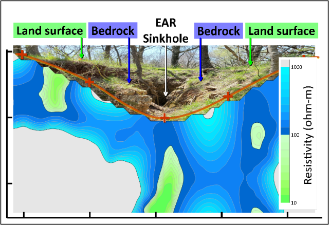
A feature of particular interest within the study area is a large sinkhole that fills up with rainwater during heavy precipitation events. The water slowly drains out in the hours after the storm, and researchers are studying where the water goes and whether it impacts the quality of the groundwater. Fields’ ERI work, recently published in the Journal of Geophysics and Engineering, sheds light on where some of the infiltrating water goes.
“We thought there were several shallow connections from the surface to the subsurface,” explains Fields, “but we were surprised at the extent of the fracturing and ‘Swiss cheese-like’ features in the images.” His team’s work confirmed the direct recharge from the sinkhole to the groundwater below it.
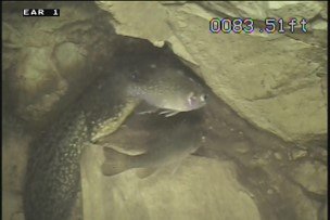
Research teams at the sinkhole site had previously found fish and tadpoles in a nearby monitoring well, an interesting phenomenon without an explanation as to how these creatures got into the borehole.

“The wells at the site are open boreholes so we can better understand the direction of flow within the aquifer, but we learned this also allowed for natural tracers to be detected with downhole cameras,” Fields says. “Fish and tadpoles live in a small pond adjacent to the sinkhole at the surface, and their transport probably occurred when the pond overflowed into the sinkhole. These ‘biotracers’ only appear in the one well that is known to be directly connected to the sinkhole. EPA researchers are also studying the potential for biological impacts to groundwater.”
The team’s ERI work confirmed the direct connection from the sinkhole to a nearby monitoring well via a karst conduit in the bedrock, a feature of further interest to the team as they try to quantify the recharge and understand groundwater transit times. The ERI team continues to gather more information about the aquifer, including new data from a deeper subsurface survey.
This research demonstrates the effectiveness of ERI to characterize Karst hydrology and its ability to define soil, bedrock, fractures, and other features of the subsurface. By locating these features, this research will help improve the design and operation of the aquifer recharge studies in the Arbuckle-Simpson Aquifer and identify study areas for additional monitoring of water quality or quantity. Tools and technology like ERI ultimately save time and money in site characterization, help protect our groundwater supply, and improve our groundwater “vision” by bringing images of this hidden resource to the surface.
Read More
Journal Article: Electrical resistivity imaging of an enhanced aquifer recharge site. Journal of Geophysics and Engineering, Volume 19, Issue 5, October 2022, Pages 1095–1110
Protecting Groundwater Resources within the Arbuckle-Simpson Aquifer in Oklahoma
