Climate Adaptation Profile: Allen Harbor Landfill, Davisville Naval Construction Battalion Center
North Kingstown, Rhode Island
Site Description
The former Davisville Naval Construction Battalion Center (NCBC) site encompasses 900 acres about 18 miles south of Providence, Rhode Island. Past onsite activities associated with NCBC operations included disposing of materials such as construction debris, paint thinners, solvents, asbestos and waste fuel oil. The disposal practices resulted in contamination of the area’s groundwater and soil as well as sediment and shellfish in the adjacent Allen Harbor. The site was added to the National Priorities List in 1989 and the NCBC closed in 1991.
Remediation Activities

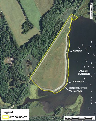
Environmental cleanup at the NCBC involves 16 operable units (OUs) including OU9, which focuses on soil and sediment remediation along Allen Harbor. The OU9 remedy involved constructing a multimedia cap above consolidated waste materials in the area known as the Allen Harbor Landfill. The remedy included constructing a stone (riprap) shoreline revetment, restoring a two-acre intertidal wetland, and constructing an offshore breakwater structure serving as a seawall. Additionally, institutional controls and a state-enforced prohibition of Allen Harbor shellfishing were established and remain in place. The Navy monitors the landfill cover system and shoreline protection structures on an annual basis.
Vulnerability to Climate Change Impacts
The Allen Harbor Landfill is situated on approximately 15 acres within a 100-year floodplain along Allen Harbor, on the western shore of Narragansett Bay. Primary vulnerabilities of the capped landfill concern erosion and overland runoff due to harbor storm surge, tidal force and wave action. Vulnerability to these natural forces is exacerbated by sea level rise. The Rhode Island Statewide Planning Program anticipates a 7-foot rise in sea level along North Kingstown within 75-100 years.
Long-term performance of the capped landfill is also sensitive to low ambient temperatures. North Kingstown temperatures in January and February average 29°F. A 2016 survey evaluating the rate of waste settlement below the cap identified elevation changes below the project benchmark of 6 inches per 100 feet over the cap’s lifespan due to freeze/thaw conditions.
Building Adaptive Capacity for Future Climate Scenarios

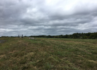
The landfill’s multimedia cap was designed to reach an elevation of at least 14 feet above mean sea level (MSL), which is above the 100-year flood elevation and higher than the 10-foot elevation specified in the earlier OU9 feasibility study. During flood conditions, the higher elevation also minimizes hydrostatic pressure on the cap components. The cap is composed (from bottom to top) of a bedding and gas transmission layer covered with a geosynthetic clay liner and geomembrane; a drainage layer covered with a geotextile; a barrier protection layer; and a soil layer that supports vegetation growth. Surfaces of the constructed cap and remaining parts of a previously emplaced soil cap were collectively graded at least 3% to promote precipitation runoff into swales that empty into the harbor.
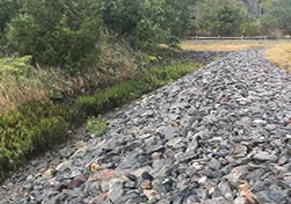
The shoreline revetment was designed to stabilize and protect the landfill surfaces from erosion during tidal rise and storm surges. The revetment is made of stone riprap of various sizing emplaced along the landfill’s entire shoreline. On the eastern shore, the upper riprap consists of 6-foot-thick stones averaging 3,000 pounds in weight and positioned in a horizontal strip spanning about 15 feet above MSL to sea level. At similar elevations on the northern and southern shores, the upper riprap consists of stones averaging 1 to 2 feet in diameter. A lower layer of riprap consisting of 3- to 6-inch stones is positioned below the upper riprap on all three shores, at elevations extending from sea level to about 15 feet below MSL. For filtering and stabilizing purposes, a layer of 1-inch stones underlays the riprap.

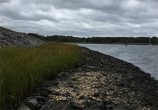
The offshore stone breakwater structure composed of riprap was constructed along the majority of the revetment length, between the harbor and the restored wetland. The structure reduces the height of waves potentially reaching the revetment during storms and consequently causing erosion.
The restored wetland additionally reduces erosive effects of localized wave action in portions of the intertidal zone where storm surge potential is highest. Wetland restoration involved removing all common reeds (Phragmites australis) and planting deep-rooted, saltwater-tolerant smooth cordgrass (Spartina alterniflora). Over time the wetlands have been naturally populated by sea lavender (Limonium carolinianum), a native species deemed suitable by the State of Connecticut for wetlands restoration in coastal environments. Both species now dominate the vigorous wetlands. Annual inspections of the wetlands have revealed development of several salt pannes (depressions) warranting continued monitoring to determine if their salinity levels are negatively affecting the wetlands plant community.

The capped landfill’s two-pronged stormwater drainage system consists of a southern drainage channel and drain, and a northern drainage channel, drain and vegetated swale. As part of long-term maintenance, the drainage system is inspected during annual sampling events and any debris and vegetation found around channel culverts are removed.
Following remedy construction, the U.S. Navy transferred ownership of the capped landfill parcel to the Town of North Kingstown for use as open space and conservation land. The Town of North Kingstown participated in a pilot project conducted by the University of Rhode Island’s Coastal Resources Center and the University of Rhode Island’s Sea Grant College Program to study climate change and sea level rise. The project produced maps and on-line data display tools to help community planners and property owners identify sea level rise vulnerabilities of local assets, including infrastructure and public property such as former NCBC parcels along Allen Harbor.
Superfund Climate Resilience
EPA provides additional information about approaches for building climate resilience at Superfund sites.
Overview of Climate Adaptation Measures
The U.S. Navy incorporated multiple resilience measures into design and construction of the Allen Harbor Landfill’s capping system:
- Raised the cap to an elevation higher than the feasibility study criteria, to at least 14 feet instead of 10 feet above MSL.
- Graded surfaces of the landfill cap to a minimum slope of 3% to promote precipitation runoff into channels and swales that empty into Allen Harbor.
- Used native plant seeds to vegetate the landfill cap’s top layer, which provides ground cover that is tolerant of the region’s seasonal temperature and precipitation extremes and minimizes the need for maintenance such as mowing.
- Constructed a revetment made of strategically sized stones along the entire length of the capped landfill's shoreline, to protect the landfill cover surfaces from erosion during tidal rise and storm surges.
- Constructed an offshore breakwater structure composed of riprap that reduces the height of waves potentially reaching the revetment during storms.
- Restored a wetland strip between the revetment and offshore breakwater structure to further reduce wave action in parts of the intertidal zone most vulnerable to erosion due to storm surge.
- Integrated two rather than one drainage channel(s) into the landfill cover system’s drainage system to provide ample capacity to quickly move rainfall and snowmelt away from the landfill cap surfaces.
Key Tools Used for Climate Projections
- Sea, Lake, and Overland Surges from Hurricanes (SLOSH), U.S. National Oceanic and Atmospheric Administration
- Sea Level Rise Viewer, U.S. National Oceanic and Atmospheric Administration
- STORMTOOLS, Rhode Island Shoreline Change Special Area Management Plan
Point of Contact
- Carol Keating, U.S. EPA Region 1
- David Barney, U.S. Navy
References
- North Kingstown, RI, Coastal Sea Level Rise and Storm Surge: Transportation Fact Sheet, Rhode Island Statewide Planning Program
- Building Blocks for Climate Adaptation: Tools for Community Assessment and Planning, Mapping Assets Vulnerable to Sea Level Rise, North Kingston, RI, Map C3, May 2011, Rhode Island Sea Grant College Program and University of Rhode Island Environmental Data Center
- Technology News and Trends, Issue No. 65, EPA 542-N-14-001, Spring 2014, U.S. EPA
- Fourth Five-Year Review Report: Former Naval Construction Battalion Center Davisville, March 2018, U.S. EPA
- Former Naval Construction Battalion Center (NCBC) Davisville Restoration Advisory Board Update, June 2021, U.S. Navy
February 2023
