Cyanobacteria Assessment Network Application (CyAN app)
User Notice: CyAN Android™ App
To continue providing critical updates and support for the CyANWeb application, EPA will no longer support the CyAN Android mobile application after December 31, 2024. All CyAN Android app users are encouraged to begin switching over to CyANWeb before support for the Android app ends. For more information, see Frequently Asked Questions.
- Compatibility and Availability
- Capabilities and Applications
- CyanoHAB Forecasts
- Background and Collaboration
- Resources
- Frequently Asked Questions
- Technical Support
Make faster decisions related to cyanobacterial algal blooms
EPA's Cyanobacteria Assessment Network web application (CyANWeb) is an easy-to-use and customizable app that provides access to cyanobacterial bloom satellite data for over 2,000 of the largest lakes and reservoirs across the United States. EPA scientists developed the app to help local and state water quality managers make faster and better-informed management decisions related to cyanobacterial blooms.
Compatibility and Availability
The CyANWeb app is a web browser-based interface available on EPA's website that will work with any operating system and is compatible with most devices. The CyAN Android™ app is no longer supported and user’s of the CyAN Android app are encouraged to use the CyANWeb app.
Disclaimer: Any mention of trade names, products, services, or enterprises does not imply an endorsement by the U.S. Government or EPA.
Capabilities and Applications

Capabilities: The CyANWeb app provides an easy to use, customizable interface to scan water bodies for changes in cyanobacteria occurrence without requiring computer programming expertise. It provides water quality managers a user-friendly platform that reduces the complexities associated with accessing satellite data to allow fast and efficient initial assessments across water bodies that are roughly one square kilometer or greater.
Users can view information about cyanobacteria concentrations on a national-scale or can zoom in to single-out data for a lake or reservoir. Because states and localities may address harmful algal blooms differently, users can determine their own thresholds for cyanobacteria concentrations. Users can also compare multiple water bodies at once, allowing for better-informed decisions based on recent changes at specific locations.

Applications: Because the CyANWeb app uses satellite data to map the location of cyanobacterial blooms in fresh and coastal waters across the U.S., it can be used to quickly inform decisions regarding recreational and drinking water safety. Lake managers, for example, could use the CyANWeb app on a daily or weekly basis to monitor lakes in their region. At a quick glance of their computer or mobile device, they could pinpoint potential problem areas and focus their attention and resources. The data might prompt them to manually collect water samples from certain lakes for more information or issue a public advisory to close local shores to recreation.
Note: The CyANWeb app is an experimental application and provides provisional satellite derived measures of cyanobacteria, which may contain errors and should be considered a research level tool. The primary satellite sensor collecting data is the European Space Agency’s Copernicus Sentinel-3 Ocean and Land Colour Instrument.
Cyanobacterial HABs Forecasting
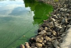
Cyanobacterial harmful algal blooms, which can appear in water bodies across the country, are an indicator of poor water quality and can potentially cause serious environmental concerns, including human and aquatic health effects. When blooms occur in recreational waters or source waters used for drinking, the toxins that may be released can cause respiratory or skin irritation and even illness in humans, domestic animals, and wildlife.
EPA researchers are working to operationalize methods to forecast when and where cyanoHABs may form. In July 2024, researchers started beta-testing an experimental cyanoHAB forecasting model to produce weekly forecasts for over 2,000 lakes across the U.S.
Learn more about EPA's Cyanobacterial HABs Forecasting Research.
Background and Research Collaboration

Historically, monitoring cyanobacteria blooms has been labor intensive and limited due to cost, time, and logistical constraints. EPA researchers are looking for ways to eliminate or reduce the negative effects of HABs on human health and the environment. Their efforts included the development of both versions of the CyAN app. The research that led to the development of the CyANWeb app and the CyAN Android™ app was conducted in collaboration with the National Aeronautics and Space Administration (NASA), the National Oceanic and Atmospheric Administration (NOAA), and the U.S. Geological Survey (USGS). Both versions were tested separately for over one year and the functionality and satellite data were successfully validated and published in multiple peer-reviewed publications.
Learn more about the CyAN Project.
Resources
User's Guides and Other Technical Resources:
- CyANWeb app user's guide
- CyAN Android™ app user's guide (deprecated)
- CyAN Android™ app training video (deprecated)
- List of resolvable lakes (.docx) (supplemental material from 2018 publication below)
Research Publications:
- Assessing the relationship between cyanobacterial blooms and respiratory-related hospital visits: Green bay, Wisconsin 2017–2019 (2024)
- Forecasting freshwater cyanobacterial harmful algal blooms for Sentinel-3 satellite resolved U.S. lakes and reservoirs (2024)
- Recent changes in cyanobacteria algal bloom magnitude in large lakes across the contiguous United States (2023)
- Evaluation of a satellite-based cyanobacteria bloom detection algorithm using field-measured microcystin data (2021)
- Exploring the potential value of satellite remote sensing to monitor chlorophyll-a for U.S. lakes and reservoirs (2020)
- Quantifying national and regional cyanobacterial occurrence in US lakes using satellite remote sensing (2020)
- Quantifying the human health benefits of using satellite information to detect cyanobacterial HABs and manage recreational advisories in U.S. lakes (2020)
- Mobile app for monitoring cyanobacteria HABs using Sentinel-3 Satellite Ocean and Land Colour instruments (2018)
- Satellite monitoring of cyanobacterial HAB frequency in recreational waters and drinking water sources (2017)
Communications and Outreach Resources:
- CyANWeb App Fact Sheet (pdf)
- CyANWeb App Palm Card (pdf)
- Science Matters article "CyAN Mobile App Helps Communities Detect Cyanobacteria in U.S. Water Bodies"
Related Resources:
Frequently Asked Questions
Why has support ended for the CyAN Android App?
The CyAN Android app provided users with vital cyanobacteria concentration estimations in large, fresh waterbodies since its public release in 2018. With the release of CyANWeb and additional feature enhancements in 2021, everything available on the CyAN Android app also became available on CyANWeb. In addition to functioning on smartphones, CyANWeb works universally across internet browsers, tablets, and personal computers, making it a more versatile tool than the CyAN Android app alone.
When did support end for the CyAN Android app?
EPA support for the CyAN Android app ended on December 31, 2024. No further software updates will be made to the CyAN Android app on the Google Play Store.
Will the CyAN data services still function after support ends?
Yes. While the CyAN Android app is no longer supported, the CyAN REST API will remain unchanged and continue to provide processed cyanobacteria index (CI) estimate data with no planned changes at this time. Any applications or users that access these services can continue to do so without disruption.
Is EPA still supporting the CyANWeb application?
Yes. EPA is dedicated to supporting CyANWeb users into 2025 and beyond.
Technical Support
Questions or comments: Contact us at the CyAN Project

