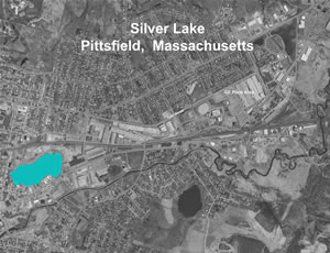
Silver Lake of the GE-Pittsfield/Housatonic River Site
Overview of the Silver Lake

Aerial Map detailing GE Project in Pittsfield, Mass.
Layout Map detailing GE Project in Pittsfield, Mass.
The Silver Lake Cleanup Area is located directly west of and across from Silver Lake Boulevard and the Former 30s Building Complex Removal Action Area and includes the lake and its banks. It is bounded to the north by Silver Lake Boulevard and Fourth Street, to the east by Silver Lake Boulevard, and to the west and south by residential and commercial properties (covering portions of 21 tax parcels). Silver Lake has a surface area of approximately 26 acres and a maximum water depth of about 30 feet. The lake currently receives stormwater flow from several City outfalls and one NPDES-permitted outfall. The NPDES-permitted outfall receives stormwater from a portion of the GE Plant Area that has been transferred to PEDA. Silver Lake discharges to the east Branch of the Housatonic River through an underground 48-inch diameter, concrete culvert pipe located in the southwest portion of the lake, near the intersection of Fenn and East Streets. This pipe conveys surface water from Silver Lake as well as stormwater runoff from Fenn and East Streets to the Housatonic River.
Silver Lake has a history of extensive contamination. PCBs had been detected (prior to remediation) in moderate to high amounts in the lake's sediment, bank soils and surface water. Historic discharges of PCBs and other chemicals in process water and wastewater from GE's operations have been reported.
Remediation of the Silver Lake Area
The Consent Decree and the August 2011 Final Removal Design/Removal Action Work Plan for the Silver Lake Area required that GE dredge 400 cubic yards of PCB "hot spot" sediment adjacent to one of the historic GE outfalls, remove additional near-shore sediment around the perimeter of the lake, clean up contaminated bank soil, and place a silty sand-based cap on the entire bottom of the lake. A 2005 bench-scale study and a 2006 one-acre pilot project of capping techniques were conducted to assist in finalizing the design of an effective fourteen-inch thick cap and cap material delivery system.
Full-scale remediation was initiated in the summer of 2012 and was substantially completed in December 2013. In addition to placement of the sediment cap, this consisted of the removal and off-site disposal of approximately 9,200 cubic yards of bank soil and debris, 400 cubic yards of sediment near a former GE outfall, and 2,900 cubic yards of soil, sediment and debris from the lower bank and near-shore sediment to allow for the placement of the shore-line cap protection system. When accounting for over excavation in these areas and the removal of temporary access road material, a total of approximately 15,815 cubic yards (20,580 tons) of bank soil, sediment, and road material was transported to licensed off-site disposal facilities. The lake's banks were restored with clean fill and native vegetation, and the sediment throughout the lake was capped with a sand-topsoil mix with a minimum in-place total organic carbon (TOC) content of 0.5%.
As part of the final bank restoration, a 2,000 foot long walking path was installed along the north and east shores, and over 1,000 native trees and shrubs were planted along with native grasses and wildflowers. In addition, some of the trees that had been cut down to implement the remedy were placed horizontally in shallow water along the shoreline to restore and enhance wildlife habitat (i.e., "woody debris" or structure).
In 2014, GE initiated post-removal site control activities, including inspection, monitoring and maintenance activities to verify that the cap is functioning as designed and to ensure other components of the remediation are functioning properly.
GE submitted a Final Completion Report (FCR) on May 8, 2015, and EPA issued a Certificate of Completion to GE on June 22, 2015. The FCR formalized GE's inspection, monitoring and maintenance requirements moving forward, with the exception of ongoing surface water sampling. GE is performing all Post-Removal Site Control Activities, including inspection, monitoring and maintenance activities as specified in the FCR.
For surface water, GE committed to a two-year post-cap sampling program consisting of monthly sampling at the outfall pipe to the Housatonic River. This program was implemented throughout 2014 and 2015, and shows significant reductions in the levels of PCBs in lake water compared to such levels prior to remediation. EPA collected split samples during many of these sampling events, and EPA's and GE's data is presented in GE’s 2014 and 2015 Annual Monitoring Reports. As of January 2016 GE has committed to continuing this sampling program going forward.
Documents related to this portion of the cleanup, including annual monitoring reports, are available under the "Reports" tab for the Silver Lake Area.
Reports for the Silver Lake
The following list of reports and documents has been selected to provide an overview of the environmental investigations and remedial actions conducted for the Silver Lake Area. Most of the available reports and documents were produced for General Electric by their environmental consultants.
- Silver Lake Sediment and Soils Adjacent to Silver Lake Reports and Related Documents
- Soils Adjacent to the Silver Lake Reports and Related Documents
- Silver Lake Sediment Reports and Related Documents
- Silver Lake Fish Tissue


